Pamukkale Drone Photography Aerial Guide
Capture Pamukkale's otherworldly beauty from above with this comprehensive guide to drone photography at Turkey's most spectacular natural wonder. From navigating complex regulations to mastering aerial composition techniques, this guide provides everything you need for successful and legal drone flights over the UNESCO World Heritage Site.
⚠️ Critical Legal Notice
Drone regulations in Turkey are strictly enforced. Pamukkale's UNESCO World Heritage status adds additional restrictions beyond standard Turkish aviation laws. This guide is current as of September 2025, but regulations change frequently. Always verify current requirements with Turkish authorities before flying.
Understanding Turkish Drone Laws 2025
Turkey maintains some of the world's most comprehensive drone regulations, particularly affecting foreign tourists visiting protected sites like Pamukkale. The country's strategic position and numerous sensitive areas have created a complex regulatory environment that demands careful navigation.
Registration Requirements for Foreign Visitors
Every drone weighing 500 grams or more must be registered with Turkey's Directorate General of Civil Aviation (DGCA). However, foreign nationals face significant restrictions that effectively limit recreational drone use:
- Tourist Restrictions: Foreign citizens cannot register as drone pilots in Turkey
- Diplomatic Clearance: Commercial or extended drone use requires FR-23 diplomatic clearance
- Advance Notice: FR-23 permits require 20 business days minimum processing time
- Technical Confirmation: Drones may be seized at customs without DGCA technical confirmation
💡 Practical Reality Check
Many visitors successfully fly drones at Pamukkale by establishing rapport with security personnel and requesting permission on-site. While this works in practice, it exists in a legal gray area. Consider this carefully based on your risk tolerance and the value of your equipment.
Flight Restrictions and Safety Parameters
Turkish aviation law establishes clear operational boundaries for all drone flights:
- Maximum Altitude: 120 meters (400 feet) above ground level
- Weight Limitation: 4 kilograms maximum for personal flights
- Distance Requirements: Minimum 50 meters from people, buildings, and vehicles
- Visual Contact: Maintain line-of-sight with aircraft at all times
- Prohibited Areas: 9 kilometers from airports, military facilities, government buildings
UNESCO World Heritage Site Considerations
Pamukkale's designation as a UNESCO World Heritage Site since 1988 introduces additional protective measures beyond standard Turkish aviation regulations. These restrictions aim to preserve both the natural travertine formations and the ancient Hierapolis archaeological site.
Archaeological Protection Zones
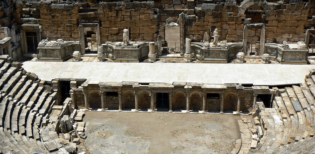
The combined Pamukkale-Hierapolis site encompasses multiple protection categories that affect drone operations. Ancient Roman ruins, including the amphitheater, necropolis, and sacred pool areas, receive heightened protection due to their irreplaceable cultural value.
Flying directly over archaeological features risks damage from equipment failure and violates cultural preservation protocols. Site management maintains strict oversight of all photography activities that could potentially impact the ruins through physical contact or electromagnetic interference with ongoing conservation efforts.
📋 UNESCO Protection Facts
- Pamukkale-Hierapolis covers 1,077 hectares of protected area
- The site includes 17 different zones with varying protection levels
- Recent conservation projects totaled €15 million in restoration work
- Annual visitor impact studies monitor environmental effects
Safety Protocols and Environmental Challenges
Pamukkale's extreme environment creates unique challenges for drone operations that extend far beyond regulatory compliance. The site's combination of mineral-rich thermal waters, intense solar radiation, and delicate geological formations demands specialized preparation and equipment protection.
Extreme Weather Considerations
Summer temperatures regularly exceed 40°C (104°F), creating thermal updrafts that affect flight stability and battery performance. The site's exposed plateau location offers no shade or shelter, intensifying heat effects on both equipment and operators.
Thermal springs generate localized humidity variations that can fog camera lenses and affect electronic components. Morning flights benefit from cooler temperatures and more stable air conditions, while afternoon operations must contend with intense heat and increased thermal turbulence.
Equipment Protection Strategies
The mineral-rich environment poses corrosion risks to drone components, particularly propellers and electronic connections. Fine calcium carbonate dust can infiltrate moving parts, while thermal spring vapors carry sulfur compounds that accelerate metal degradation.
- Battery Management: Extreme heat reduces battery life and performance; carry extras and shade equipment
- Lens Protection: Use UV filters and lens hoods to prevent mineral deposits and thermal distortion
- Corrosion Prevention: Clean equipment immediately after flights to remove mineral residue
- Storage Considerations: Keep gear in insulated cases to prevent thermal shock
🌡️ Heat Safety Alert
Personal safety is paramount. Operators have experienced mild sunstroke even with protection. Carry excessive water, seek shade frequently, and consider morning flights to avoid peak temperatures. Heat-related emergencies can occur rapidly in this environment.
Optimal Photography Techniques and Composition
Pamukkale's unique geological formations offer extraordinary aerial photography opportunities that reward technical excellence and creative vision. The site's geometric patterns, mineral contrasts, and three-dimensional cascade structures create compelling subjects for various photographic approaches.
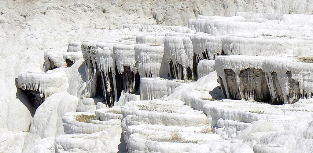
Capturing the Travertine Terraces
The cascading calcium carbonate pools form natural leading lines and geometric patterns that translate beautifully to aerial photography. Different altitudes reveal varying levels of detail, from intimate pool formations to sweeping landscape vistas.
Low-altitude perspectives (30-50 meters) emphasize individual pool details and water reflections, capturing the intricate rim patterns and subtle color variations. These shots reveal the delicate scalloped edges and mineral deposits that define each terrace's character.
Medium-altitude views (70-100 meters) showcase the interconnected cascade structure, demonstrating how thermal springs flow between levels and create the iconic stepped appearance. This perspective balances detail with context, showing both individual pools and their relationship to the overall formation.
High-altitude shots (100-120 meters) capture the complete geological picture, revealing Pamukkale's position within the broader Lycus River valley landscape and its relationship to the ancient Hierapolis ruins above.
Abstract Pattern Photography
Direct overhead shooting transforms Pamukkale's organic forms into abstract compositions reminiscent of modern art installations. The contrast between pure white calcium carbonate and brilliant blue thermal water creates striking minimalist imagery.
Focus on the geometric relationships between pool shapes, emphasizing curves, angles, and negative spaces. The interplay of shadows and highlights across mineral deposits adds depth and texture to these abstract compositions.
📸 Professional Photography Tips
- Golden Hour Advantage: Early morning and late afternoon provide warm light that enhances mineral textures
- Polarizing Filters: Reduce water glare and enhance contrast between white minerals and blue pools
- Multiple Exposures: Bracket shots to capture both bright mineral deposits and dark pool depths
- Focus Stacking: Combine multiple focal planes for maximum detail in complex formations
Strategic Flight Planning and Timing
Successful drone photography at Pamukkale requires careful timing coordination that balances optimal lighting conditions, crowd management, regulatory considerations, and environmental factors. The site's popularity and operational restrictions create narrow windows for ideal shooting conditions.
Crowd Avoidance Strategies
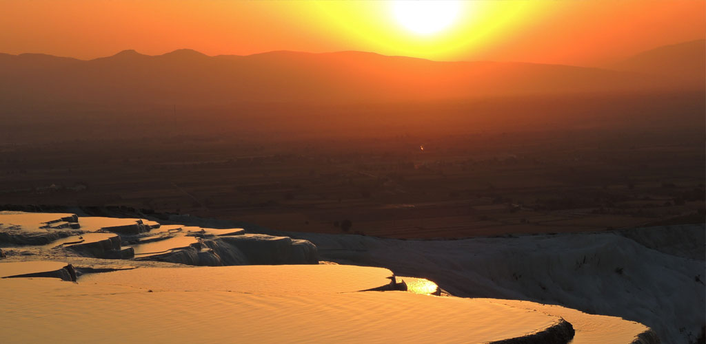
Pamukkale receives over 1.7 million annual visitors, with peak concentrations during midday hours and tour group arrival times. Early morning flights (6:00-8:00 AM) offer the best combination of minimal crowds, optimal lighting, and cooler temperatures.
Tour buses typically arrive between 10:00 AM and 2:00 PM, creating significant crowd density that complicates drone operations and reduces photographic opportunities. Late afternoon sessions (4:00-6:00 PM) provide another crowd-reduced window, though with increased thermal challenges.
Seasonal Considerations
Winter months (December-February) offer unique advantages for drone photography, including reduced visitor numbers, stable weather patterns, and comfortable operating temperatures. Snow occasionally contrasts dramatically with thermal pool areas, creating rare photographic opportunities.
Spring and autumn provide ideal conditions with moderate temperatures, excellent visibility, and reasonable crowd levels. Summer operations require extreme caution due to heat effects on both equipment and operators.
Equipment Recommendations and Technical Settings
Pamukkale's challenging environment demands specific equipment considerations and technical approaches to achieve professional results while protecting valuable gear from extreme conditions.
Drone Selection Criteria
Choose drones with excellent flight stability and redundant safety systems for operations near the UNESCO World Heritage Site. Wind resistance capabilities prove essential given the site's exposed plateau location and thermal updrafts from hot springs.
Recommended specifications:
- Flight Time: Minimum 25 minutes to allow positioning and multiple shot attempts
- Camera Quality: 4K minimum with manual exposure controls for challenging lighting
- Obstacle Avoidance: Multi-directional sensors for safety near crowds and structures
- Temperature Rating: Extended operating range for extreme heat conditions
Camera Settings for Mineral Formations
Pamukkale's extreme contrast between bright white minerals and dark water pools challenges standard camera settings. Manual exposure control becomes essential for achieving proper detail in both highlights and shadows.
Technical recommendations:
- ISO: Keep at 100-200 to minimize noise in high-contrast scenes
- Aperture: f/2.8-f/4 for optimal sharpness while maintaining depth of field
- Shutter Speed: Minimum 1/120s to prevent motion blur from thermal updrafts
- Color Space: RAW format essential for post-processing extreme dynamic range
🔧 Post-Processing Essentials
Pamukkale imagery benefits significantly from careful post-processing to balance the extreme contrast between minerals and water. Focus on highlight recovery, shadow lifting, and local contrast enhancement to reveal the full detail range captured in RAW files.
Alternative Aerial Photography Options
For visitors unable to navigate drone regulations or preferring guaranteed access, several alternative approaches provide spectacular aerial perspectives of Pamukkale while ensuring complete legal compliance and safety.
Hot Air Balloon Photography
Professional hot air balloon operations offer commercially licensed aerial photography opportunities with experienced pilots familiar with local regulations and optimal viewing angles. These flights provide extended shooting time and multiple perspective options impossible with standard drone operations.
Balloon flights typically operate during early morning hours when air conditions remain stable and lighting proves optimal for photography. The elevated perspective reveals Pamukkale's relationship to surrounding geological features and the broader Lycus River valley landscape.
Booking considerations:
- Advance Reservations: Popular operators require 2-3 days minimum booking time
- Weather Dependencies: Flights cancel for wind or poor visibility conditions
- Equipment Policies: Verify camera gear restrictions and insurance coverage
- Group Size: Smaller baskets provide better photography positioning options
Professional Helicopter Services
Charter helicopter services provide ultimate flexibility for aerial photography, offering precise positioning control and extended flight time for complex shots. Professional operators maintain proper licensing for UNESCO site overflights and understand regulatory requirements.
Helicopter charters allow custom flight paths, multiple altitude options, and door-removal services for unobstructed photography. Costs reflect the premium service level but provide guaranteed access and professional support.
Ethical Considerations and Cultural Sensitivity
Responsible drone photography at Pamukkale extends beyond legal compliance to encompass respect for cultural heritage, environmental protection, and the experiences of fellow visitors. UNESCO World Heritage Sites deserve special consideration that acknowledges their global significance.
Minimizing Environmental Impact
Pamukkale's delicate travertine formations result from thousands of years of mineral deposition that continues today through thermal spring activity. Any disruption to this process threatens the site's natural integrity and future preservation.
Avoid low flights over active spring sources where propeller wash might disturb mineral-rich water flow patterns. Maintain appropriate distances from sensitive formation edges where calcium carbonate buildup occurs most actively.
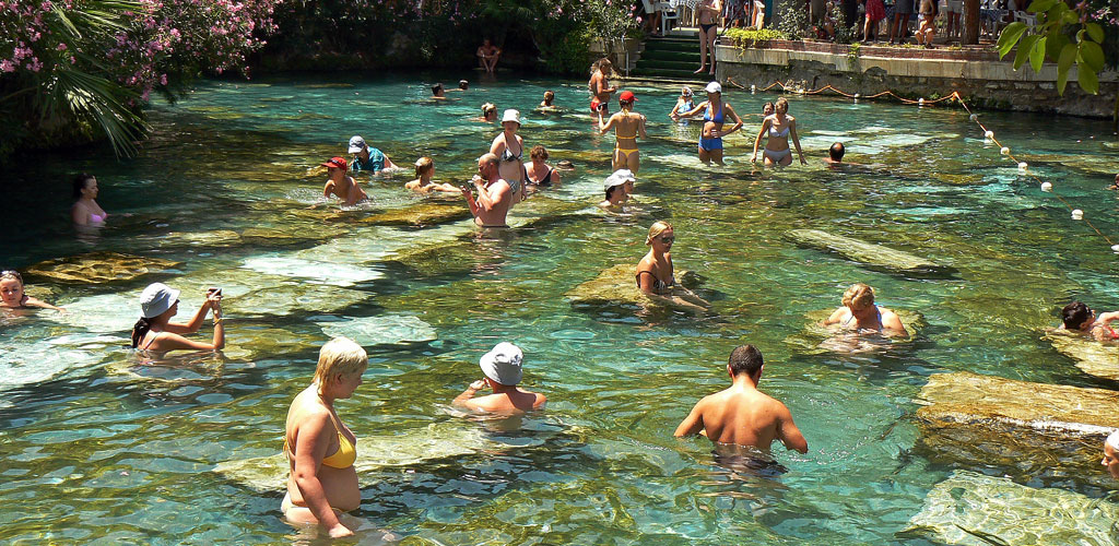
Respecting Visitor Experiences
Many visitors travel great distances to experience Pamukkale's tranquil beauty and historical significance. Drone noise and visual intrusion can significantly impact these experiences, particularly during quiet morning or evening hours when natural sounds should dominate.
Consider photography timing that minimizes impact on meditation, cultural reflection, and intimate family moments that define meaningful travel experiences for many visitors.
🌍 Global Heritage Responsibility
Pamukkale belongs to all humanity through its UNESCO designation. Every visitor bears responsibility for preserving this irreplaceable site for future generations. Consider how your photography activities contribute to or detract from this preservation mission.
Risk Management and Emergency Procedures
Drone operations at Pamukkale involve multiple risk factors that require advance planning and emergency preparedness. The remote location, extreme environment, and regulatory complexity create scenarios requiring immediate response capabilities.
Equipment Recovery Scenarios
Thermal spring areas present unique challenges for equipment recovery following crashes or emergency landings. Hot water temperatures reach 35-100°C, creating immediate danger for retrieval attempts. Mineral-rich water accelerates corrosion, making rapid recovery essential.
Establish clear communication with site management before flights to understand emergency procedures and available assistance. Identify safe approach routes to potential landing areas and emergency contact protocols.
Medical Emergency Preparedness
The extreme heat and remote location increase risks of heat-related illness, dehydration, and equipment-related injuries. Pamukkale's location requires 30-45 minutes for emergency medical response from Denizli city center.
Essential preparation includes:
- Communication: Ensure reliable cell phone coverage and emergency contact information
- Hydration: Carry excessive water and electrolyte replacement supplies
- Shelter: Portable shade options for extended operations
- First Aid: Heat illness treatment supplies and basic medical kit
Future Developments and Regulation Changes
Turkish drone regulations continue evolving rapidly as the country balances tourism promotion with security concerns and heritage protection. Recent developments suggest increasingly sophisticated approaches to recreational drone management.
Digital Permit Systems
Turkey's aviation authority is developing digital permit systems that may simplify tourist drone operations while maintaining security oversight. These systems could provide real-time flight authorization for specific areas and time periods.
Geofencing technology integration may create automated compliance systems that prevent flights in restricted areas while allowing approved operations in designated zones. This development could significantly improve tourist access while ensuring regulatory compliance.
Site-Specific Tourism Integration
UNESCO site management increasingly recognizes drone photography's value for promoting heritage tourism while maintaining protection standards. Future regulations may establish specific viewing zones, approved flight paths, and professional photography permit categories.
🔄 Staying Current
Drone regulations change frequently. Before traveling, check current requirements through official Turkish aviation authorities (DGCA), UNESCO site management, and recent traveler reports from reliable sources. Join drone photography communities for real-time updates from recent visitors.
Conclusion: Capturing Pamukkale's Aerial Magic
Drone photography at Pamukkale offers extraordinary opportunities to capture one of Earth's most remarkable geological phenomena from perspectives impossible through traditional photography. The combination of pristine white travertine terraces, brilliant blue thermal pools, and ancient archaeological ruins creates compositions of unparalleled beauty.
Success requires careful navigation of complex regulations, respect for cultural heritage values, and preparation for extreme environmental conditions. Whether through legal drone operations, alternative aerial platforms, or creative ground-based techniques, the goal remains consistent: preserving and sharing Pamukkale's timeless beauty while protecting this irreplaceable UNESCO World Heritage Site for future generations.
The memories and images captured through responsible aerial photography contribute to global appreciation for Turkey's natural wonders while supporting the conservation efforts that ensure Pamukkale's preservation. Every stunning aerial photograph serves as both artistic achievement and conservation advocacy, inspiring others to visit, experience, and protect this remarkable destination.
Plan carefully, fly safely, and capture the magic that has captivated visitors to Pamukkale for over two millennia. The white cotton castle awaits your creative vision from above.